Lesson 1B: Keep it simple
Users generally want things that are easy to learn and use. So keep your spatial data publication platform as simple as possible...
Because different users have different expertise, knowledge and skills. So, do not bother users with specialist features or data. For example, GIS-experts have more experience in editing and converting map objects than non-GIS-users.
A platform that enables to easily upload and publish spatial data sets.
Keep complicated stuff behind the front door.
For example, do not ask users to fill in a coordinate reference system (CRS) when they upload a spatial data set. Generally, the CRS can be detected from the CRS embedded in the file.
GeoJSON:
{ "type": "FeatureCollection",
"crs": { "type": "name", "properties": { "name": "urn:ogc:def:crs:OGC:1.3:CRS84" } },
"features": [ ...
Geography Markup Language (GML):
<gml:Polygon srsName="EPSG:4326"> ...
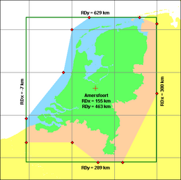
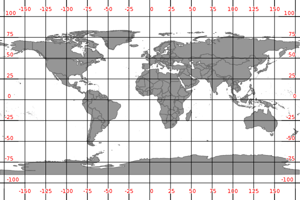
Alternatively if the CRS is missing, you could more or less extract or predict the CRS based on the user profile. For example, a user from The Netherlands will most likely upload a spatial dataset having CRS WGS'84 (EPSG:4326), with coordinates between -90;+90 (lat) and -180;+180 (lon) or CRS Rijksdriehoekstelsel with coordinates between 0,000;300,000 (x) and 300,000;600,000 (y).
After uploading a spatial data set,
- a coordinate transformation can be run on the dataset, for example using PostGIS
ST_Transform(geom, 4326)to transform geometry to CRS WGS'84. - the dataset can be reprojected upon visualization, for example using Leaflet plugin Proj4Leaflet by adding
'crs': { 'type': 'name', 'properties': { 'name': 'urn:ogc:def:crs:EPSG::4326' } }
to reproject GeoJSON-features to WGS'84.
In the second phase of the testbed we have seen how to simplify the implementation of Linked Geodata, which is notoriously complex usually. Examples can be found in chapter 5 of https://github.com/geo4web-testbed/topic1-task1/blob/master/report/main.pdf
Usability testing