This repository contains the following tools:
- tile_downloader for downloading orthophoto tiles, which are used for texturing the generated meshes.
- terrainbuilder for building the highest quality meshes from the downloaded orthophoto tiles and a heightmap dataset.
- terrainmerger for building a LOD hierarchy from the highest quality meshes by merging them upwards.
- terrainconvert for converting .tile files into .glb files.
terrainlib contains classes common to all the tools above.
The tools typically only handle one tile per command which makes it infeasible to run them manually for a whole region due to the sheer amount of tiles. Therefore, we've created the following python scripts, which automate calling the relevant tools for a specified regions:
- batch-builder.py calls terrainbuilder for all tiles in the specified region.
- batch-merger.py calls terrainmerger for all tiles in the specified region.
- batch-converter.py calls terrainconvert for all .tile files in the specified directory and its subdirectories.
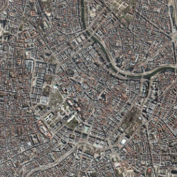
In this example, we'll show how to build the hierarchy for Vienna's city center (Zoom: 13, X: 4468, Y:2840).
The following command will download the basemap tiles from our mirror with the following format: https://gataki.cg.tuwien.ac.at/raw/basemap/tiles/{zoom}/{Y}/{X}.jpeg
Example for the root tile: https://gataki.cg.tuwien.ac.at/raw/basemap/tiles/13/2840/4468.jpeg
The tiles will be downloaded into the folder ./tiles/.
./tile-downloader --provider gataki --zoom 13 --row 2840 --col 4468 --max-zoom-level 19
The meshes are built from a heightmap dataset, therefore we need to download one. For this example we'll only use a small part of the complete dataset for the whole of austria (available at https://gataki.cg.tuwien.ac.at/raw/Oe_2020/, 268 GB to 1.1 TB). The part we're gonna use contains Vienna's city center and it is available at https://gataki.cg.tuwien.ac.at/raw/vienna/innenstadt_gs_1m_mgi.tif (228 MB).

The following command will build reference meshes for the root tile 13/4468/2840 at the target zoom level 19 from the tile textures in ./tiles/ and the dataset ./innenstadt_gs_1m_mgi.tif and output them in the folder ./meshes. The SRS used is EPSG:3857, as the demo renderer expects coordinates in the WebMercator (EPSG:3857) system.
python3 batch-builder.py --terrainbuilder ./terrainbuilder --tile 13 4468 2840 --target-zoom 19 --output-dir ./meshes -- --textures ./tiles/ --dataset ./innenstadt_gs_1m_mgi.tif --mesh-srs EPSG:3857
The following command will build the LOD hierarchy from the reference meshes generated in the previous step at ./meshes and output simplified GLB/GLTF files at ./hierarchy/{zoom}/{Y}/{X}.simplified.glb.
Warning
This process is very time intensive and may end up taking hours depending on the region size!
python3 batch-merger.py --terrainmerger ./terrainmerger --root-tile 13 4468 2840 --max-zoom 19 --input-dir ./meshes --output-dir ./hierarchy
Due to the separation of concerns in step 3. Building reference meshes the tilebuilder does not output .GLB files, and in step 4. Building tile hierarchy by merging and simplifying reference meshes the terrainmerger only outputs simplified GLB files for the next higher level. Therefore, there are no GLB files present for the highest zoom level 19. Fortunately, there is the terrainconvert tool, which enables the conversion between .TILE and .GLB files without simplification.
The following command runs a script, which checks if there is a *.simplified.glb file for every *.tile present.
Note
Even though we name the converted GLB files using the suffix .simplified.glb, there is no simplification happening during the conversion. This naming is only used for consistency's sake, as the terrainmerger creates GLB files with this suffix and the demo renderer expects a consistent naming scheme. You could also, in theory, rename the whole hierarchy to just use *.glb, make the relevant change in the demo renderer and it would work too.
python3 batch-converter.py --terrainconverter ./terrainconvert --dir ./hierarchy/19 --suffix .simplified
To make the tiles accessible to the demo renderer just serve the final hierarchy via a http(s) server, which the computer running the demo renderer can access. The default URL format used by the demo renderer is /{zoom}/{Y}/{X}.simplified.glb.
See Modifying the tile server URL for information on how to change the server URL, file structure and suffix.
In order to build, you need to install:
- fmt (https://fmt.dev/latest/index.html)
- GDAL 3 (https://gdal.org/)
- glm (https://github.com/g-truc/glm)
- catch2 (version 2.x) (https://github.com/catchorg/Catch2/tree/v2.x)
- FreeImage
- tbb (intel threading building blocks)
sudo apt-get install libfmt-dev libglm-dev libgdal-dev catch2 libfreeimage-dev libtbb-dev