ClockBoard for 30 world cites #32
Replies: 7 comments 4 replies
-
|
This is so cool @mtennekes thanks for making this happen, ideal for the paper! |
Beta Was this translation helpful? Give feedback.
-
|
In terms of discussion points...
Agreed, this is a strength of our approach. Great discussion point.
Seems OK to me and good enough for now. I suggest trying Google's geocoding service (e.g. in
Agreed. |
Beta Was this translation helpful? Give feedback.
-
|
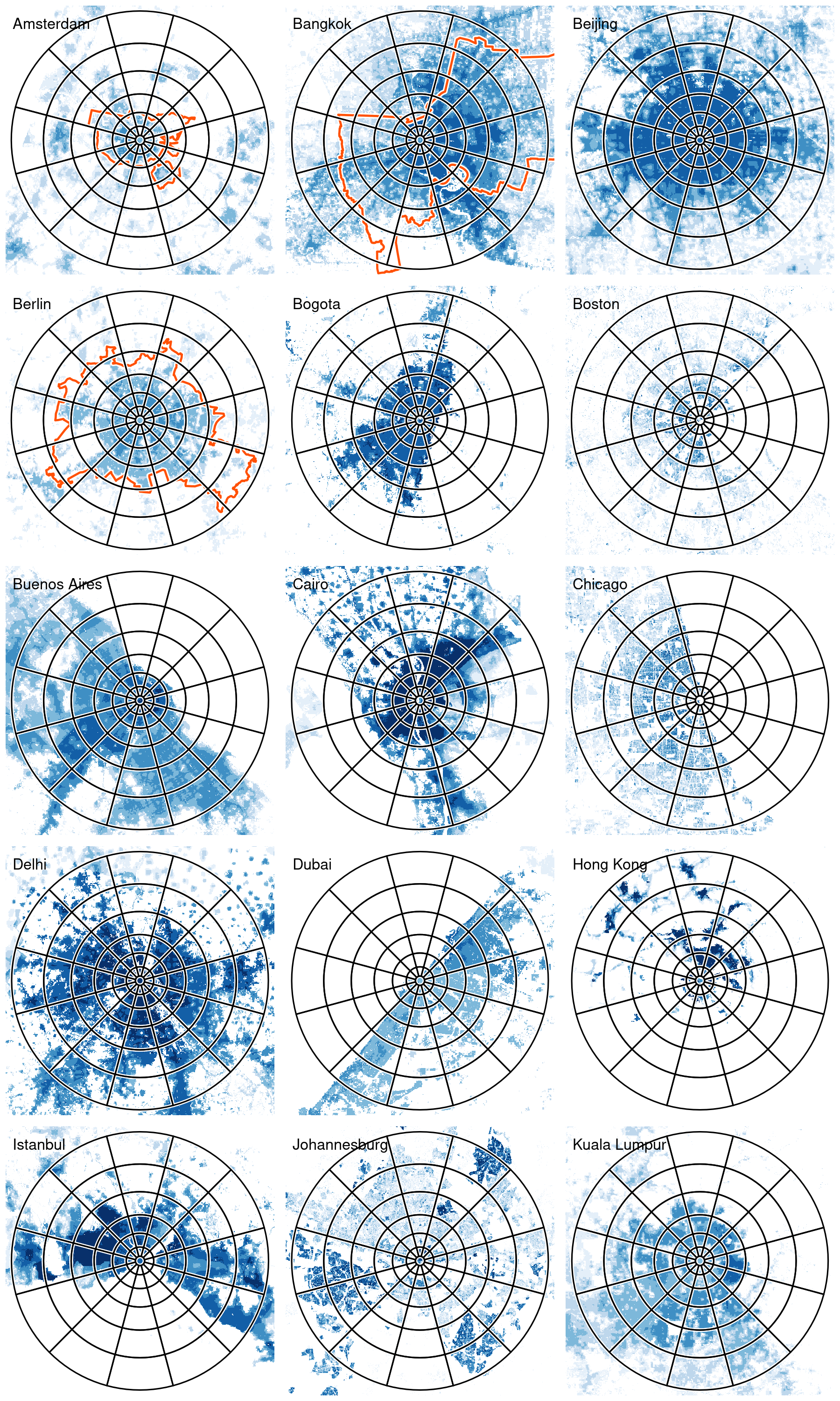
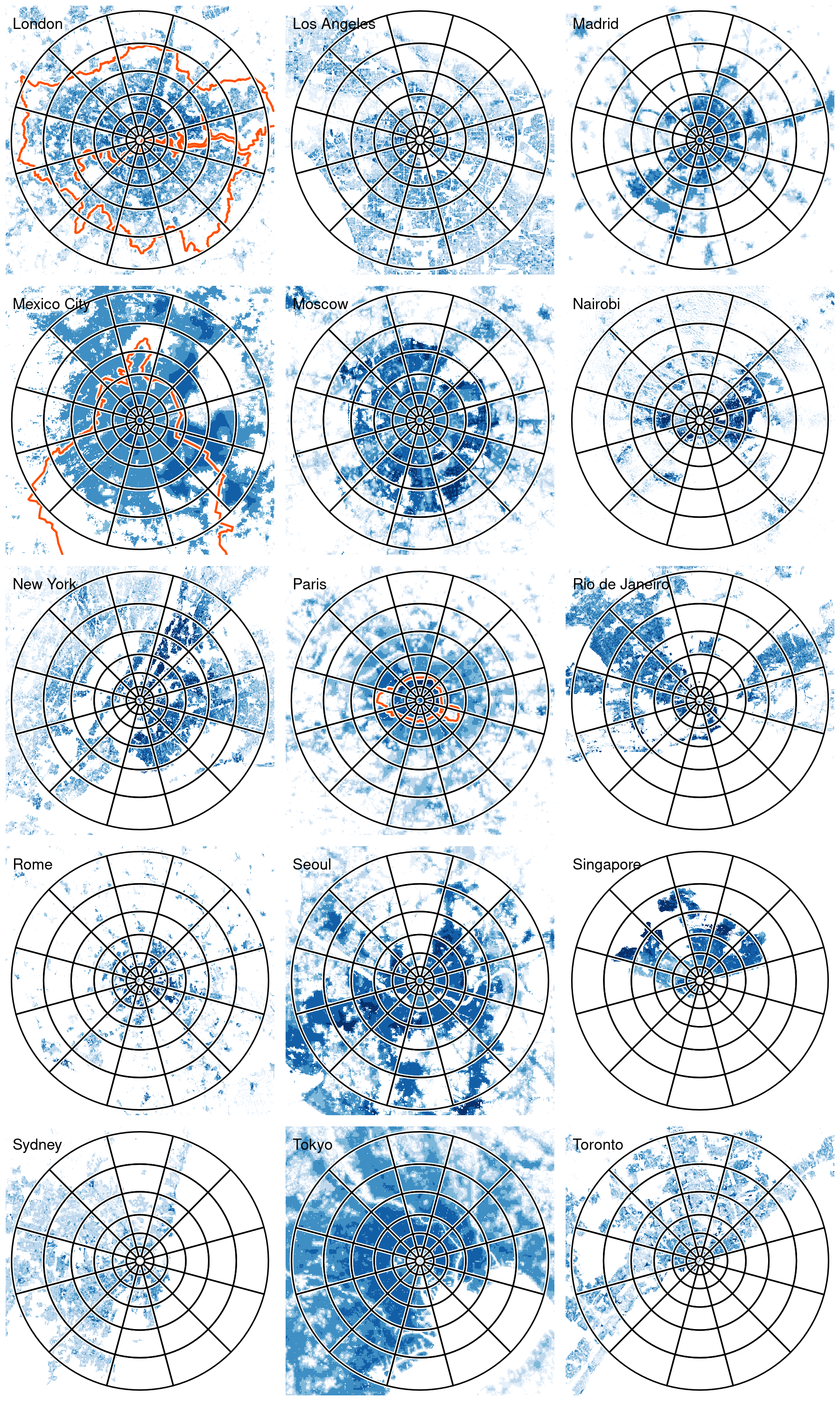
Thx, I'll add the results of Google's geocoding to the list of sources. This example illustrates that one of our challenges is how to decide how many circles are recommended per city. I like your term 'sphere of influences' (mentioned in #30). That should be leading, although hard to quantify. Maybe we can come up with something like a "buzz"yness indicator per grid cell and try fit Gaussian distributions (spheres) that represent the cities. But that is something for another paper;-) I've also included Amsterdam, not because of its size (it is not even a town compared to most of the other cities), but it is a good example of an urban area. The whole area is called the Randstad and has a total population of about 8 million. You may recognize Utrecht, which is the spot in H5. The Hague and Rotterdam are just outside the Clockboard (J8 and K7 respectively). |
Beta Was this translation helpful? Give feedback.
-
|
I think the urban areas in The Netherlands are good: if it can work there in the highly polycentric conurbations it can surely work anywhere! Let me know next steps on the paper. |
Beta Was this translation helpful? Give feedback.
-
|
Quick thought on this @mtennekes: remove the 2 outer rings in all cases. That will mean some cities have boundaries going outside and that will be fine. |
Beta Was this translation helpful? Give feedback.
-
|
Great suggestion @Robinlovelace : |
Beta Was this translation helpful? Give feedback.
-
|
Looking good! improvement 4 sure. |
Beta Was this translation helpful? Give feedback.
-
|
Next steps for the paper: I think it would be good to focus on the whole paper until applications. So I mean the intro (which is almost there), the method section, and probably something like a 'face validity' section in which we can use these charts; we can discuss how well the CB fits in certain cities and where potential problems are. |
Beta Was this translation helpful? Give feedback.
-
|
OK, will take a look today. I may call if I have questions. |
Beta Was this translation helpful? Give feedback.
-
|
Please do. This month I am extremely busy with other projects, so I expect to have time in April. We should aim to finish the paper by than. |
Beta Was this translation helpful? Give feedback.
-
|
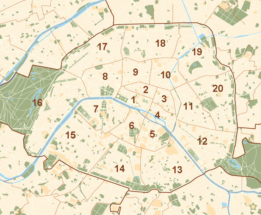
B.t.w. the arrangements of Paris have a 'zonebuiler'-esque structure, but the labeling is not easy for navigation purposes: |
Beta Was this translation helpful? Give feedback.
Uh oh!
There was an error while loading. Please reload this page.
-
Info:
Some observations / points of discussion:
tmaptools::geocode_OSM) and the metropolitan data from naturalearthdata (themetrodataset oftmap). For each city, I've selected the best one (as far as I could judge). Does anyone know a good dataset for that?Beta Was this translation helpful? Give feedback.
All reactions